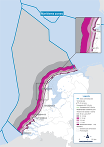
Within the territorial sea
The territorial sea comprises five zones that are bounded by lines at 1 kilometre, 1 mile, 3 miles, 6 miles and 12 miles off the coast.
Dutch territorial sea
Extends to 12 nautical miles from the low-water mark. This is the area within which the Dutch laws apply.
Municipal/provincial boundary
Used for administrative purposes. The powers of the provinces located on the coast extend to 1 kilometre off the coast with slight deviations in the Zeeland Delta and the Wadden Islands. The area beyond is managed by the central government.
Zone up to 1 nautical mile
Up to this boundary, the Ecological Condition of the Water Framework Directive applies.
Zone up to 3 nautical miles
This is the former outer boundary of the territorial sea, which was maintained for the mining legislation when the territorial sea was extended to 12 nautical miles in 1985. After the recent revision of the Mining Act, this zone largely lost its the significance. The zone is still important for fisheries: in addition to the Dutch, Belgians are also allowed to fish within the 3-mile zone (under the Benelux Treaty).
Zone from 3 to 6 nautical miles
Fishermen from the Netherlands, Belgium, Luxembourg, Denmark and Germany are allowed fish for certain species in this zone.
Zone from 6 to 12 nautical miles
Fishermen from the Netherlands, Belgium, Luxembourg, Denmark, Germany and Great Britain are allowed fish for certain species in this zone.
Continuous Amsterdam Ordnance Datum – 20 m line of depth
This line of depth is considered the boundary line of the coastal foundation and is especially important for the regulation on excavation; these are not allowed landward of this limit. The line of depth also serves as the outer limit of the Natura 2000 areas.
Share this