
Hollandse Kust (zuid) Wind Farm Zone including Offshore Wind Farm Luchterduinen (LUD)
Particulars of the wind farm
The Hollandse Kust (zuid/south) Wind Farm Zone is made up of four sites and the Luchterduinen offshore wind farm (operational since 2015). Sites I and II lie completely outside the 12 nautical mile-zone. The other two sites, III and IV, lie partially in a strip between 10 and 12 nautical miles from the coast of Zuid-Holland. The wind farms can be seen from the coast. The electricity is brought to land near the Maasvlakte by transmission cables and, from there, distributed to the national electricity grid.
The part of the wind farm zone outside the 12 nautical mile zone has been designated in the National Water Plan 2009-2015. The government's National Structural Vision Offshore Wind Energy Hollandse Kust Zone (2016) adds a strip, within the 12 nautical mile zone, to the previously designated wind farm zone.
|
Location: Off the coast of Zuid-Holland |
Hollandse Kust (zuid), sites I - IV | Luchterduinen |
|---|---|---|
|
In use from |
2023 |
2015 |
|
In use untill |
2049 |
2034 |
|
Number of wind turbines |
19 |
43 |
|
Turbine output (MW) |
11 |
3 |
|
Wind farm output (MW) |
1529 |
129 |
|
Surface area (km2) |
214 |
16 |
|
Operators |
Sites
The permits for all sites of the Hollandse Kust (zuid) wind farm zone have been allocated to Vattenfall. Vattenfall started work on construction of the wind farm in July 2021. At the beginning of August 2022, Hollandse Kust (zuid) supplied the first electricity to the Dutch electricity grid. Construction has been completed in 2023. The offshore windfarm has been operational since autumn 2023.
You can find all reports and decisions on the website of RVO Bureau energieprojecten. Here, you will find documents such as:
- the Range and Detail Memorandum (NRD);
- the Environmental Impact Report;
- the site decisions.
Through shipping
The North Sea Programme 2022-2027 establishes the policy for through shipping and shared use in wind farm zones on the Dutch section of the North Sea. This implies that through shipping may solely pass through a wind farm zone or individual wind farm in the designated passageway. Outside the passageway, entry is prohibited except for access traffic.
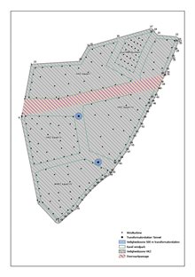
A passageway has been set up in the Hollandse Kust (zuid) wind farm zone which allows through shipping for vessels of up to 46 metres under certain conditions. The conditions for use of the passage are as follows:
- Passage is permitted day and night within the boundaries of the passage.
- This applies solely to vessels with a length less than 46 metres (LOA/Length Overall).
- Operational Automatic Identification System (AIS) and marine VHF radio are mandatory.
- A distance of at least 150 metres from the wind turbines must be maintained at all times in the passageway.
Use of a fishing rod is permitted in the passageway, where this does not lead to disruption or potentially hazardous situations for other shipping. To clarify how the passageway should be used a Code of Conduct (pdf, 128 kB) has been compiled.
The passageway is marked with lateral fairway markers. The safety zone for Hollandse Kust (zuid), including the passageway, is shown on international nautical charts.
See also the Administrative Ruling of General Application (B.A.S.) establishing a safety zone for the Hollandse Kust (zuid) wind farm zone (B.A.S. HKZ), which is published in the Government Gazette (pdf, 1 MB).
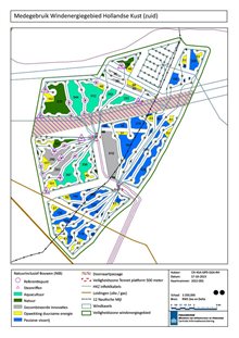
Shared use
In line with the North Sea Programme 2022-2027, the following sorts of shared use are possible in offshore wind farms:
- aquaculture (including seafood and seaweed);
- other forms of renewable energy generation and storage (including solar, wave or tidal energy);
- projects promoting nature (e.g. oyster recovery, fish refuges, artificial reefs);
- passive fishing (including crab traps and lobster creels).
An Area Passport guide has been drawn up for the Hollandse Kust (zuid) wind farm zone. This guide uses features specific to the area to indicate where shared use is possible, which forms of this have the greatest chance of success and can best be accommodated and, as such, are preferable.
For a shared-use initiative in a wind farm zone it is necessary, among other things, to apply for a permit under the Water Act. The following video takes you through the application process.
Hollandse Kust (zuid) Wind Farm Zone including Offshore Wind Farm Luchterduinen (LUD)
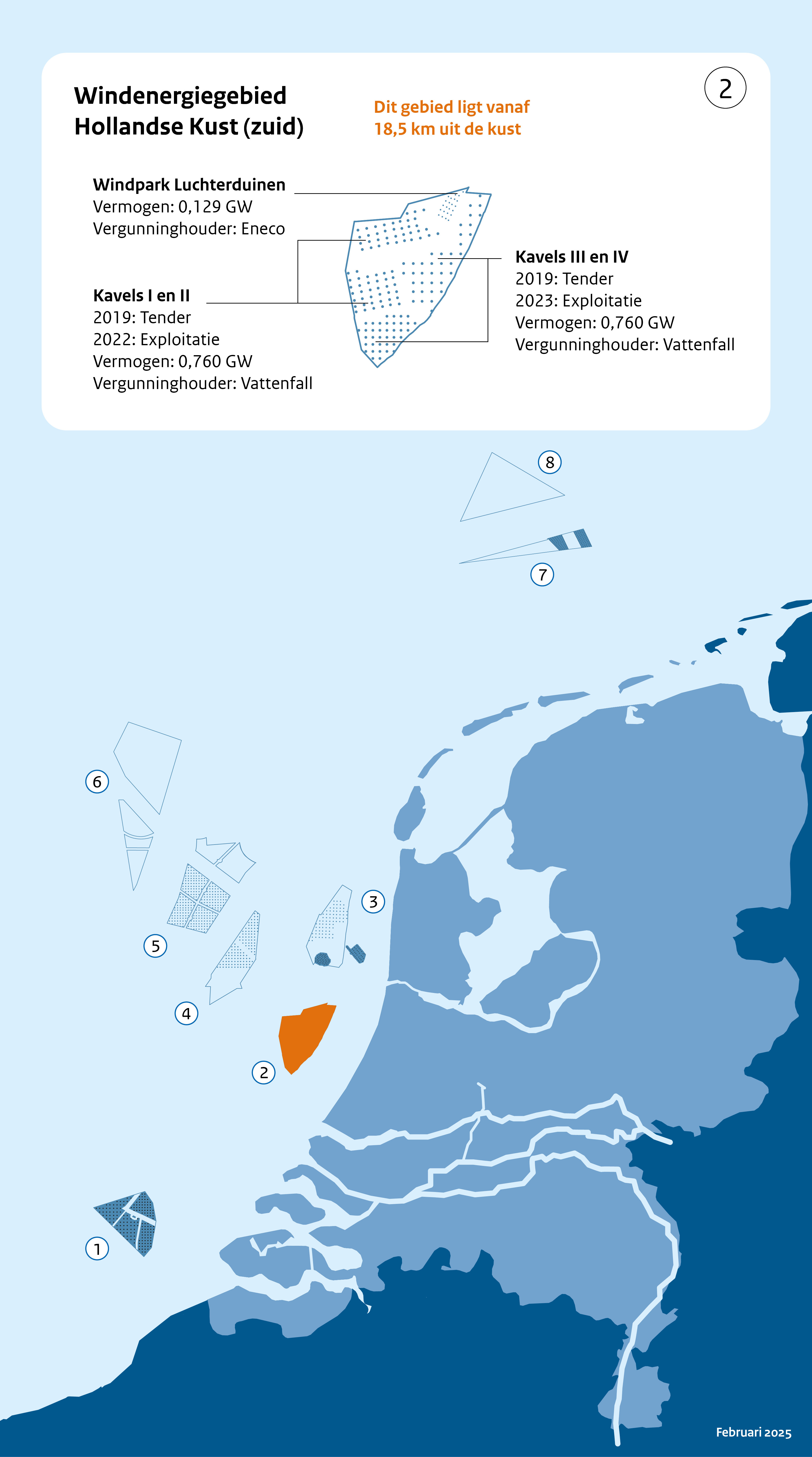
Legend Hollandse Kust (zuid) Wind Farm Zone including Offshore Wind Farm Luchterduinen (LUD):
- Kavel = Site
- Vermogen = Output
- Exploitatie = Operation
- Vergunninghouder = Permit holder
- Dit gebied ligt vanaf 18.5 km uit de kust = This zone lies from 18.5 km off the coastline
- Bestaande windparken = Existing wind farms
- Toekomstige windparken = Future wind farms