
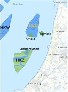
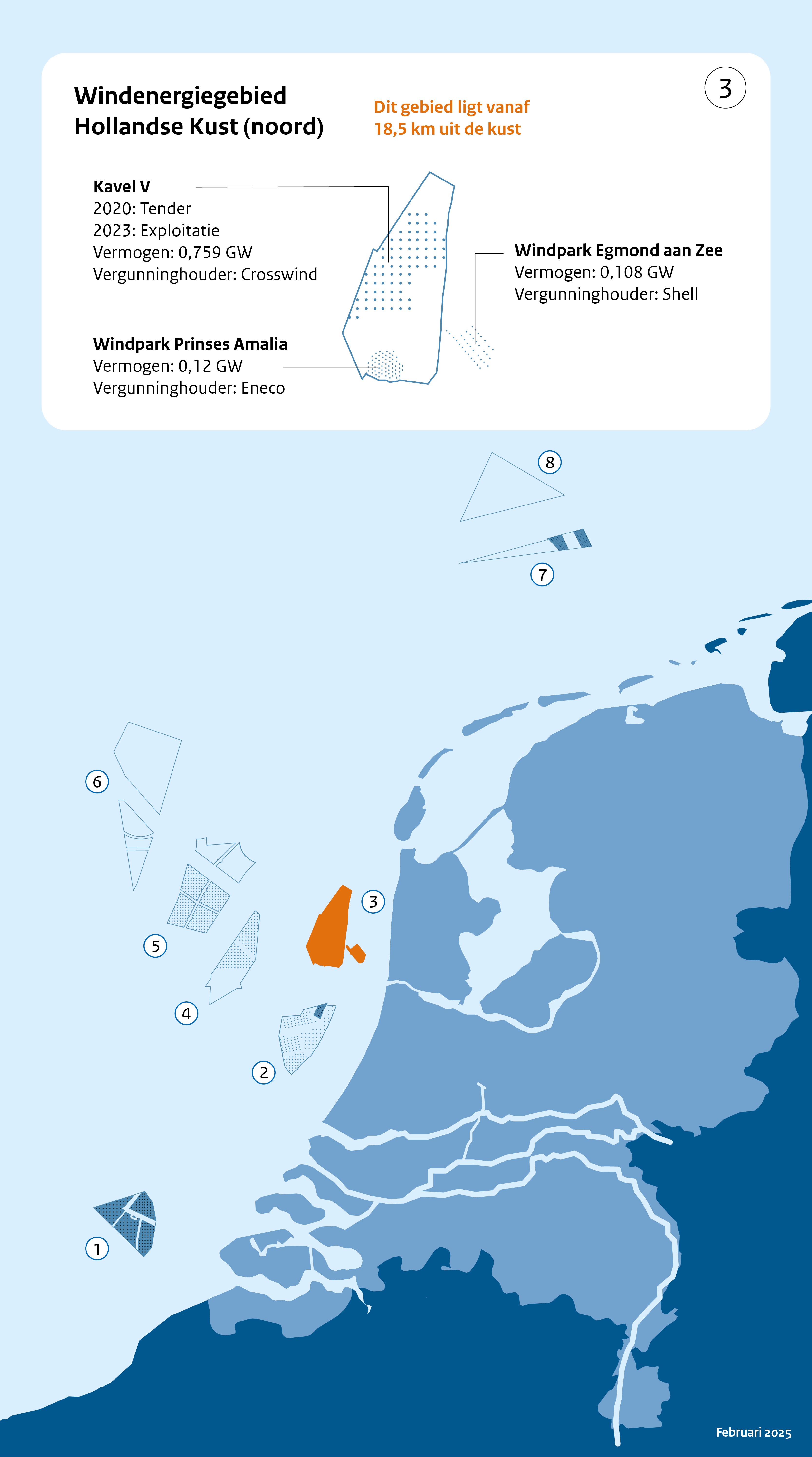
Hollandse Kust (noord) wind farm zone including Prinses Amalia Wind Farm (PAWF)
Particulars of the wind farm
The Prinses Amalia Wind Farm, which has been operational since 2008, is located in the southern part of the Hollandse Kust (north) wind farm zone. Since 2023 a second wind farm has been operational in site V, in the northern part of the wind farm zone. The electricity of the wind farms will be brought to land near Wijk aan Zee by transmission cables and, from there, distributed to the national electricity grid. The Hollandse Kust (north) wind farm zone is partially within the 12 nautical mile zone. The Prinses Amalia Wind Farm and the new wind farm in site V can be seen from the coast in clear conditions.
The part of the wind farm zone outside the 12 nautical mile zone was designated in the National Water Plan 2009-2015. The The government's National Structural Vision Offshore Wind Energy Hollandse Kust Additional Area adds a strip within the 12 nautical mile zone, to the previously designated wind farm zone. The whole Hollandse Kust (north) wind farm zone covers an area of 290 km².
|
Location: Off the coast of Noord-Holland |
Hollandse Kust (noord) site V | Prinses Amalia Windpark |
|---|---|---|
|
In use from |
2023 |
2008 |
|
In use untill |
2050 |
2028 |
|
Number of wind turbines |
69 |
60 |
|
Turbine output (MW) |
11 |
2 |
|
Wind farm output (MW) |
759 |
120 |
|
Surface area (km2) |
126 |
14 |
|
Operators |
Sites
It was decided not to reserve the whole wind farm zone for the construction of wind farms, rather to apply the principle of compact building design. So, in addition to the Prinses Amalia Wind Farm, there is space for a wind farm in site V with a capacity of over 700 MW. This wind farm includes 96 wind turbines. The total surface area for site V is approx. 126 km2.
The permit for site V in the Hollandse Kust (north) wind farm zone has been awarded to Crosswind, a joint-venture of Shell and Eneco. Construction work on the wind farm started in October 2022; the wind farm has been in use sinse 2023.
You can find all reports and decisions on the website of RVO Bureau energieprojecten. Here, you will find documents such as:
- the Range and Detail Memorandum (NRD);
- the Environmental Impact Report;
- the site decision.
Free passage
Since april 2018 the Prinses Amalia Wind Farm has solely been accessible to vessels with a length of up to 24 metres under specific conditions; fishing with a line is permitted.
See for the conditions also the Administrative Ruling of General Application (BAS) establishing a safety zone for the Prinses Amalia Wind Farm.
The Code of Conduct (pdf, 180 kB) for safe passage through wind farms specifies the rules and safety tips for shipping passing through this wind farm.
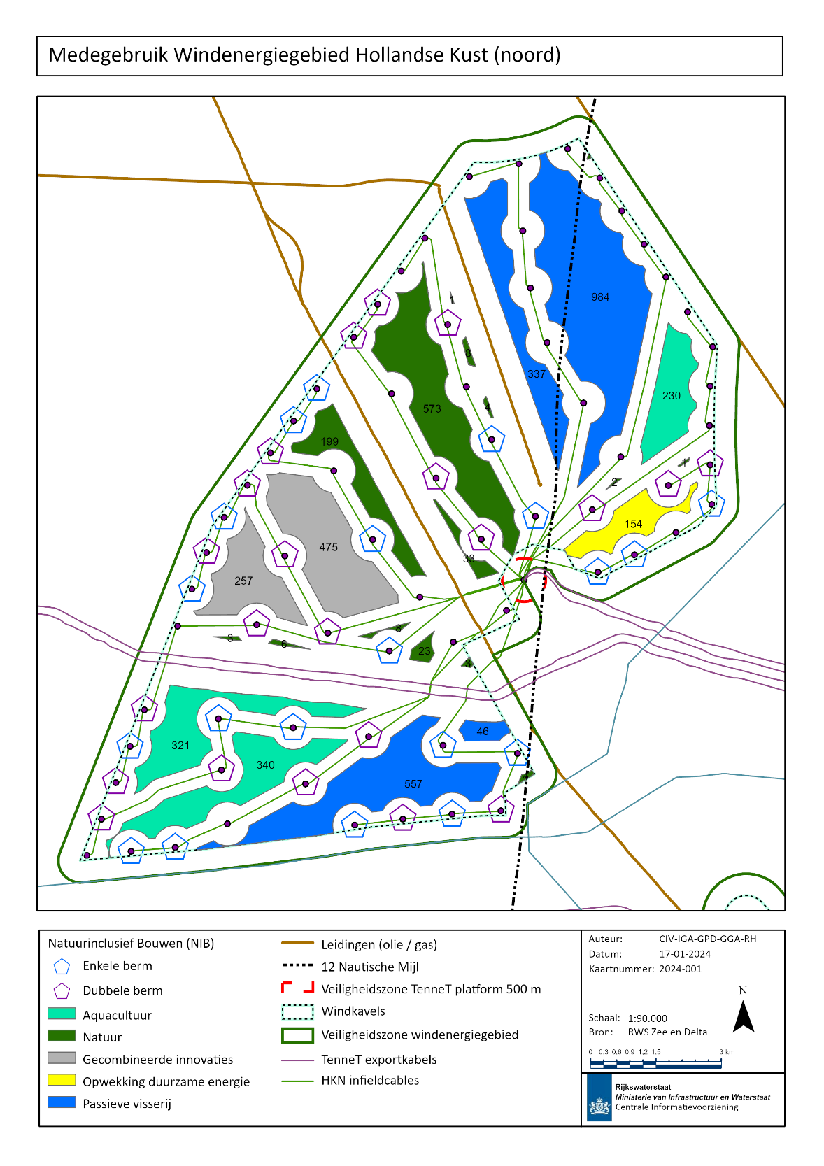
Not the entire remaining part of the Hollandse Kust (noord) wind farm zone has been used for the new wind farm. That's why a strip of open sea of approximately 4 km wide (see figure 1) can be used as a passageway for all ships to pass through the wind farm zone.
Because there are sufficient passage options for shipping through the wind farm zone, there is no need to designate a passage in the wind farm in site V. The open sea space in the wind farm zone can also be used for other activities that are not permitted in wind farms, such as seabed disturbing fishing.
There is a blanket ban on access within site V, which means that the site is available to access traffic only.
See also the Administrative Ruling of General Application site V Hollandse Kust (noord) (BAS HKN), published in the Government Gazette (February 1, 2024).
Shared use
In line with the North Sea Programme 2022-2027, the following sorts of shared use are possible in offshore wind farms:
- aquaculture (including seafood and seaweed);
- other forms of renewable energy generation and storage (including solar, wave or tidal energy);
- projects promoting nature (e.g. oyster recovery, fish refuges, artificial reefs);
- passive fishing (including crab traps and lobster creels).
An Area Passport guide has been drawn up for the wind farm in site V of the Hollandse Kust (noord) wind farm zone. This guide uses features specific to the area to indicate where shared use is possible, which forms of this have the greatest chance of success and can best be accommodated and, as such, are preferable (figure 2).
Due to the passage for ships smaller than 24 meters and the limited space between the wind turbines, no shared use with fixed structures is permitted in the Princes Amalia Wind Farm. As a result, the Area Passport guide only applies to the wind farm in site V of the Hollandse Kust (noord) wind farm zone.

Download as a larger picture (png, 484 kB)
For a shared use initiative in a wind farm, a permit under the Environmental Act (Omgevingswet) must be applied for, among other permits.
Movie Shared use Hollandse Kust (noord) - click on the image
Innovations
The tender for Hollandse Kust (noord) for the first time includes provisions to stimulate innovations that contribute to increasing the flexibility of the supply profile of future offshore wind farms. Crosswind is therefore carrying out two innovation experiments with other forms of renewable energy:
- generation of energy through floating solar panels (0.5 MW);
- installation of a Baseload Power Hub, which consists of a battery and a small hydrogen platform. Here, hydrogen is produced from electricity, stored and converted back into electricity.
The floating solar park is electrically connected to the Baseload Power Hub. The plot on which this innovations will take place has therefore been fully allocated in the Area Passport for other forms of renewable energy.
Hollandse Kust (noord) wind farm zone including Prinses Amalia Wind Farm (PAWF)
Legend Hollandse Kust (noord) wind farm zone including Prinses Amalia Wind Farm (PAWF):
- Kavel = Site
- Vermogen = Output
- Exploitatie = Operation
- Vergunninghouder = Permit holder
- Dit gebied ligt vanaf 18.5 km uit de kust = This zone lies from 18.5 km off the coastline
- Bestaande windparken = Existing wind farms
- Toekomstige windparken = Future wind farms